Winter 2023
Tunnel Top Triumph
How the Presidio of San Francisco got rid of an aging, ugly freeway — and scored new national parkland in the process.
My husband and I were locking up our bikes a few blocks away from the new Presidio Tunnel Tops when we first registered a high-pitched din, wafting on the breeze blowing off San Francisco Bay.
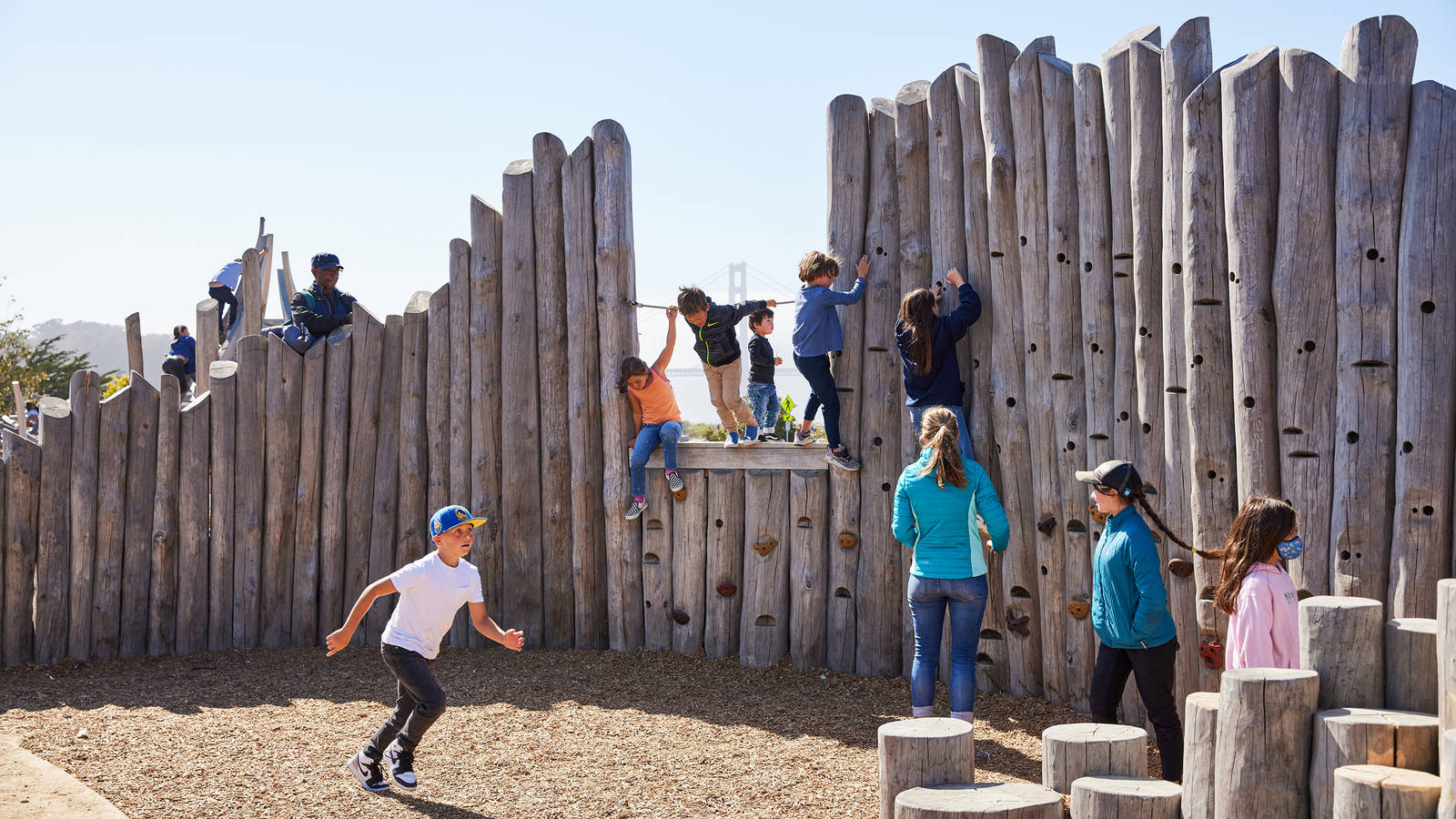
We walked closer. The noise grew louder. Then we rounded a corner and discovered its source: hundreds and hundreds of kids, joyfully screaming their heads off while romping around a sprawling playground at the foot of a bluff rising from the bay shore. Kids scrambled up granite crags, careened down concrete slides and hopscotched between sidewalk murals depicting poppies, hummingbirds and dozens of other California species.
My husband and I, who are in our mid-30s and childless, were astounded by how cool this playground is. But what’s even more astounding is that just 10 years ago, the land the playground sits on, and the steep bluff carpeted with native plants behind it, didn’t even exist. It’s all part of Presidio Tunnel Tops, 14 acres of new parkland built over a six-lane freeway. The completion of Tunnel Tops marks a milestone in the ongoing effort to transform San Francisco’s northern gateway from an off-limits Army base into a national park site that’s accessible and welcoming to all.
This park, which has been packed with people every weekend since it opened in July, is part of a $1 billion project that began three decades ago with the need to replace a hazardous expressway called Doyle Drive. The 1.6-mile elevated expressway was built in 1936 to funnel drivers between the Golden Gate Bridge and downtown, passing right over the Presidio, which was then the oldest active military base on the West Coast.

Heading for the Hills
Treating the lockdown blues with a close-to-home adventure in Golden Gate National Recreation Area.
See more ›But in 1988, a federal commission proposed closing the Presidio as an Army base, setting a course for the land to eventually be transferred to the National Park Service and become part of Golden Gate National Recreation Area. What’s more, after the 1989 Loma Prieta earthquake rattled Doyle Drive’s aging foundations, engineers determined that the expressway was not likely to withstand another such shock. Doyle Drive was now a rickety barrier blocking access to what would soon become San Francisco’s newest national park site. So in 1991, San Franciscans began the process of replacing Doyle Drive with a new gateway to the city that would better meet the Presidio’s evolving identity.
A local landscape architect and concerned citizen named Michael Painter came forward with the winning idea: Rather than replacing Doyle Drive with another hulking viaduct, or worse, building a traditional freeway at ground level, Painter pitched a roadway routed through tunnels covered in parkland. Thousands of cars a day could still pass through the Presidio, while overhead, hikers and bikers could follow trails sloping down to the bay. (Today Tunnel Tops covers the eastern tunnels, and an additional 6 acres of new parkland, Battery Bluff, cover the western tunnels. The California Department of Transportation helped fund the restoration of a marsh and other areas damaged by construction for a total of 50 acres of revitalized parkland.)
TAKE A CLOSER LOOK
“I see this place as part of a much larger movement, which is about putting people first in our cities, rather than putting cars first,” said Michael Boland, who led design and public engagement for Tunnel Tops as chief park officer for the Presidio Trust, the agency that manages the Presidio in collaboration with the Park Service. Projects that have rerouted or removed freeways to create more pedestrian-friendly public spaces include the tunnel that replaced the Alaskan Way Viaduct in downtown Seattle, Tom McCall Waterfront Park in Portland, Oregon, and Boston’s Big Dig. And in San Francisco, the removal of the old Embarcadero Freeway in the early 1990s revived a stretch of the city’s waterfront from the Bay Bridge to Fisherman’s Wharf.
The effort to replace Doyle Drive had already been underway for two decades by the time I moved in next door. In 2013, I took an internship with the Presidio Trust, just as the agency was launching the public process to design the parkland that would cover the tunnels and the nonprofit Golden Gate National Parks Conservancy was starting to raise $98 million in private donations to build the park. (The Presidio Trust contributed an additional $20 million.) Meanwhile, the California Department of Transportation had begun building the new freeway and the tunnels it would pass through. For the year I lived and worked in the Presidio, my commute was a 10-minute walk skirting the freeway construction site, a yawning gulch from which dump trucks, clouds of dust and startling explosions issued routinely.
So it was pleasantly surreal, nine years later, to weave through crowds of people packing the mosaic of lawns and gardens on top of the tunnels and head across an old military parade ground to the door of my former office. From there, we walked west to check out Battery Bluff, named for four gun batteries built around the turn of the 20th century. Two of them were partially buried during the construction of Doyle Drive back in the 1930s, but portions of the batteries have been excavated and restored and are now open for the public to explore.

National Parks
You can read this and other stories about history, nature, culture, art, conservation, travel, science and more in National Parks magazine. Your tax-deductible membership donation of $25 or more entitles…
See more ›“Hopefully we’re in an era of much greater social consciousness than the era of freeway building, and the way this bad infrastructure has destroyed communities across the country is recognized and acknowledged,” said Jim Chappell. He’s the former head of the San Francisco Bay Area Planning and Urban Research Association, or SPUR, a nonprofit that helped convene agencies and community members to replace Doyle Drive, and he’s been involved since the project’s earliest days. “I think when people come to the Presidio and see what we’ve accomplished, they will demand better in their own communities.”
After a morning of exploration, we were ready to check out the offerings from the dozen or so food trucks parked along the curb next to Tunnel Tops. We decided on a flight of empanadas and snagged a vacant patch of grass. While we ate, we gawked at the wide-angle view spanning from the Golden Gate Bridge and the Marin Headlands in the west, Angel Island and Alcatraz to the north, and the downtown San Francisco skyline to the east. All the while, a steady stream of cars rolled under our feet, unseen and unheard.
About the author
-
 Julia Busiek Author
Julia Busiek is a writer living in Oakland. She's worked in national parks in Washington, Hawaii, Colorado and California.

-
Press Release
President Trump Signs Order to Slash Bears Ears and Grand Staircase-Escalante National Monuments in Utah
"President Trump’s order to slash protections for Bears Ears and Grand Staircase-Escalante is both a betrayal to the American people and illegal. No president has the authority to erase or…
-
Press Release
Cadiz Pipeline Permit Threatens Mojave Desert Groundwater
“The facts are clear. This groundwater mining proposal would drain the desert and rob the Mojave of its rare springs and wildlife habitat."—NPCA's Chance Wilcox, California Desert Associate Director
-
Press Release
Court Reverses Decision on Bears Ears and Grand Staircase-Escalante National Monuments, Sends Back to U.S. District Court in Utah
"These monuments were never meant to be on a political roller coaster. The Antiquities Act is clear: it gives presidents the authority to designate national monuments, but no president has…


