Fall 2023
On The Brink
What happens when erosion, rising seas, a national park and a beach community collide?
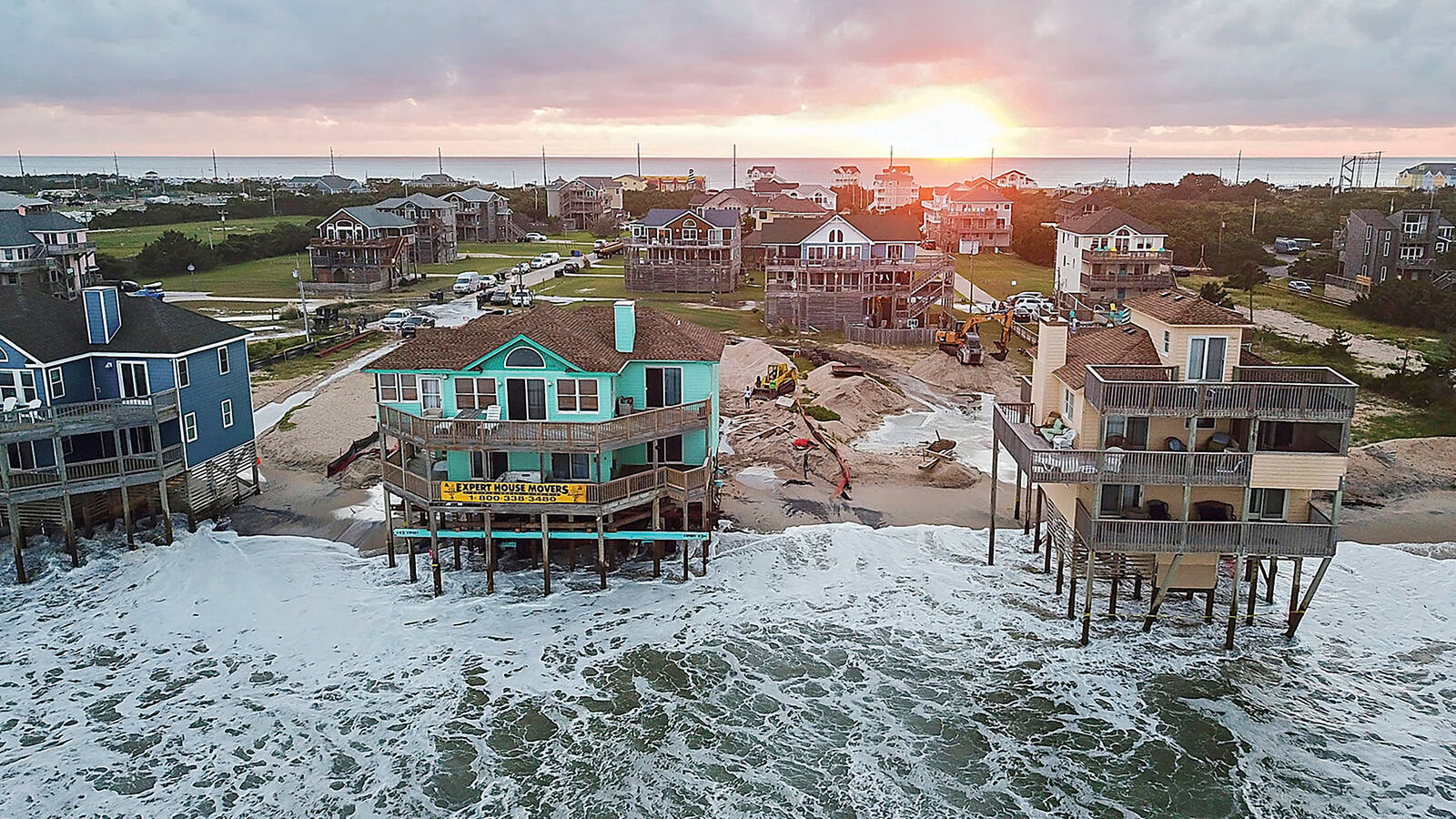
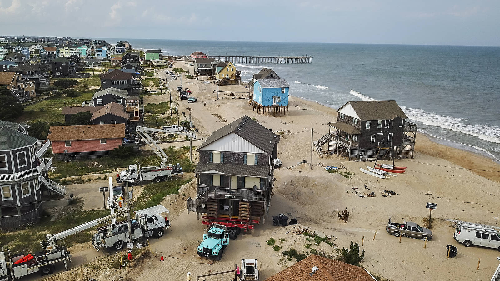
Shortly after sunrise in mid-January, I parked my car behind a few pickup trucks on South Shore Drive in the village of Rodanthe, North Carolina — one of seven villages on Hatteras Island. Wearing a lightweight jacket and shin-high yellow rubber boots, I walked past mounds of sand and piles of wood planks toward a house raised about 20 feet on temporary risers that looked like giant Jenga blocks. Workers busied themselves around the construction site, and in the background, trucks grunted and generators hummed, drowning out the sound of the Atlantic Ocean.
This cheery, aqua-colored house, with two stories and five bedrooms, belongs to Cindy Doughty, a retired nurse. She and her late husband were enthusiastic world travelers, but over the years, they had fallen in love with the simplicity and calm of the area. They kept returning, and two decades ago, the couple purchased their own place. Their vacation home, where they brought their kids (and later, their grandkids) looks out to Cape Hatteras National Seashore, which protects 75 miles of Atlantic coastline in the Outer Banks.
Doughty recalled how her family used to lug gear out a long boardwalk and over a dune to reach the surf. But over the years, the distance between the ocean and Doughty’s house shrank, and that’s when her troubles began. First, a storm blew out some stairs from the house; that was a relatively easy thing to fix. But in 2019, a hurricane came through and wiped out the entire dune between her house and the ocean.
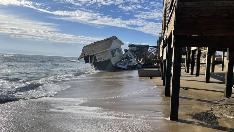
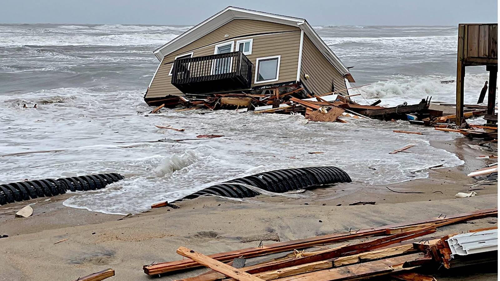
“Once that was gone,” Doughty said, “water came up under the house with every storm.” In February 2022, a house on Ocean Drive, 300 yards to the north, collapsed into the water, hungry waves devouring the entire structure and then spitting two-by-fours, drywall, shingles, tar paper and furniture onto the shoreline for miles. Large chunks of concrete slammed into Doughty’s house and broke the oceanside door. Then when two more homes fell a few months later, the detritus destroyed the back of her home. Water lines snapped, the pilings broke, and the house became uninhabitable.
Shoreline Erosion at Cape Hatteras National Seashore
Collapsing homes and beach debris create new challenges for the National Park Service.
See more ›Doughty had a seasonal job managing a clothing shop in Duck, about an hour away, so she slept in her boss’s guest room for several months. Some evenings, she returned to Rodanthe and sat in her home, alone. There wasn’t any electricity, but the moon reflected off the ocean and lit up the house. She thought about how she used to keep her bedroom sliding door open, the sound of the waves lulling her to sleep.
“This sounds silly, but I wanted to keep the house company,” Doughty said. “I know every detail of that house like I know the wrinkles on my face. It was heartbreaking to see it all hurt and busted up.” Yet she was luckier than most: The home was on a double lot, so she had room to shift it away from the water, like scooting back your beach towel as the tide comes in. Moving her house, she decided, was the only option.
I arrived in Rodanthe when Doughty was mid-move. I’d traveled there not only to talk to homeowners but also to learn more about the messy situation that washes up when coastal erosion, private homes and a national park cross paths. A warming climate — which is causing rising seas and more intense, frequent storms — has been catastrophic for coastal regions around the world. Here in the Outer Banks, a string of fragile barrier islands, the sea has been engulfing beach homes one by one, which is a nightmare for homeowners and a disaster for the local government and the National Park Service. Beaches covered with dangerous debris are terrible for wildlife, and viral videos of house collapses are awful for tourism. Even if most of the beach is unsullied, “if you’re in Iowa and you’re deciding about the Outer Banks and see news of 2 miles of Rodanthe covered with debris from fallen houses, you’re going to go somewhere else,” said Bobby Outten, the manager of Dare County, which stretches along 110 miles of the coast.
But the search for solutions has laid bare some inherent tensions between those with competing priorities. On the one hand, the Park Service is in the business of protecting this beautiful, beloved beach and the wildlife here — from hundreds of bird species to five endangered or threatened species of turtles. Because the shoreline has shifted so dramatically and the national seashore’s boundary is based in part on that shifting shoreline, it is likely that some Rodanthe homes in danger of collapse now partially or completely sit inside the national park site. Moving or removing the houses, which would please many environmentalists, likely would be the best way to protect the seashore.
On the other hand, many owners of imperiled homes are reluctant — or unable — to move their houses. They tend to prefer the idea of beach nourishment, an engineering feat and temporary fix that involves adding tons of sand to the eroding shoreline to protect residences.
Figuring out what to do will require answering some important questions: Where exactly are the national seashore boundaries today in relation to private property? What is an appropriate role for the Park Service, which once actively protected the coast from erosion? What are the responsibilities of homeowners, some of whom made the decision to buy oceanfront properties in recent years even though waves were pushing toward the houses and the low selling prices underscored how risky the investments were? Should the government or anyone else bail them out? By the time I arrived in Rodanthe, the tightknit village was consumed in a heated debate about all of this. As I looked at Doughty’s house, I began to understand the complexity of the situation.

Ghost crabs are just one of the many species impacted by debris from falling houses at Cape Hatteras National Seashore.
KEVIN T. EDWARDS/USGS.GOVI waded into the surf to take a picture of the house. As I stepped backward to frame my shot, I looked behind me to gauge the incoming waves. In the seconds I turned away from the surf, a wave snuck up, dumping icy saltwater into my boots and soaking my jeans. I laughed out loud. And I felt certain that the mighty, unpredictable ocean was laughing back.
People who vacation in the Outer Banks — or OBX, as the area is known — talk about the destination as though it’s from another time: tranquil, quaint, wholesome. Even in places where the Banks are more developed, the area is worlds apart from much of the Maryland, Delaware and New Jersey shores, with their high-rise hotels and bustling boardwalks. Those who seek an even slower pace head to the national seashore, which extends along the coastline from just south of Nags Head to the southern terminus of Ocracoke Island. Visitors to these islands tend to follow similar summertime rituals: They rent homes, stock up on groceries, play on the beach by day and grill on the deck by night.
After I visited Doughty’s home, I drove to Whalebone Junction — the northernmost point of Cape Hatteras National Seashore — to meet the park’s superintendent, David Hallac, who had agreed to show me around Rodanthe. Under overcast skies, we headed down Highway 12, a two-lane road where sand regularly blows or washes onto the pavement, like watercolors bleeding outside an ink line. This is Hallac’s ninth year working in the Outer Banks, where he also oversees Fort Raleigh National Historic Site and Wright Brothers National Memorial. Among locals, he has earned a reputation for fairness and peacemaking. He is soft-spoken and smiles a little as he talks, as though he’s sharing a secret. Rob Young, director of the Program for the Study of Developed Shorelines at Western Carolina University, called him a “superhero superintendent” with one of the hardest jobs in the Park Service. Together, Hallac and I headed toward Ocean Drive, where three residences collapsed in 2022.
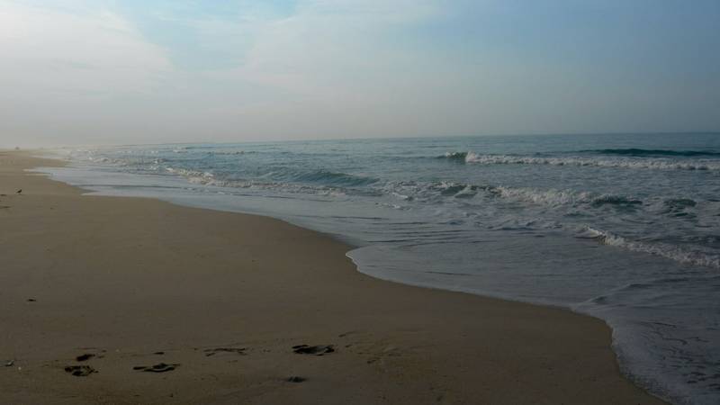
The unincorporated village of Rodanthe sits about halfway down Hatteras, jutting out into the Atlantic Ocean. Young said the village is in an especially exposed and vulnerable spot. Here, the shoreline moves 10 to 15 feet every year — triple the rate on some other parts of the island. Along the 2 miles at the northern end of Rodanthe, the dry sand part of the beach that is owned by the Park Service is virtually gone — as are the dunes that once protected homes and roads. Of course, the problem isn’t limited to Rodanthe. Cape Point, at the south end of Hatteras Island, for instance, has probably moved more in the last three years than Rodanthe has since 1950. But that isn’t newsworthy because there aren’t any structures at risk.
©KAREN MINOT
In developed areas across the United States, erosion is leading to devastation: Homes are falling into the ocean in Cape Cod, Massachusetts, and railroad tracks are shifting along the coast in San Clemente, California. The shorelines would recede without climate change, according to experts, but sea-level rise accelerates the problem. The National Oceanic and Atmospheric Administration projects as much sea-level rise in the next 30 years as we’ve recorded in the past century. By 2050, “moderate” flooding, which the agency defines as “typically damaging,” is expected to occur an average of 10 times more often than it does today, and a study published earlier this year shows seas along the Southeast and Gulf coasts have risen at unprecedented rates.
Braxton Davis, the director of North Carolina’s division of coastal management, said imagery from 2020 showed that 764 of nearly 9,000 oceanfront structures in the state were at risk at that time. He estimated that at least 20 have collapsed over the past two decades.
When a house collapses, debris can stretch 20 miles along the national seashore, making it unsafe for beachgoers. “It renders miles of beach unusable,” said Julie Furr Youngman, a senior attorney at the Southern Environmental Law Center who works on coastal protection and water quality issues. “It’s not just the risk of people being hurt during the actual collapse that’s so terrible,” she said. “It’s the raw sewage, boards with nails and insulation. Even cleaning up the largest items takes a long time; fully cleaning up the smallest items like nails, broken glass and scraps of carpet has proven nearly impossible.” In one count, the Park Service found 33 exposed septic tanks and drain fields.
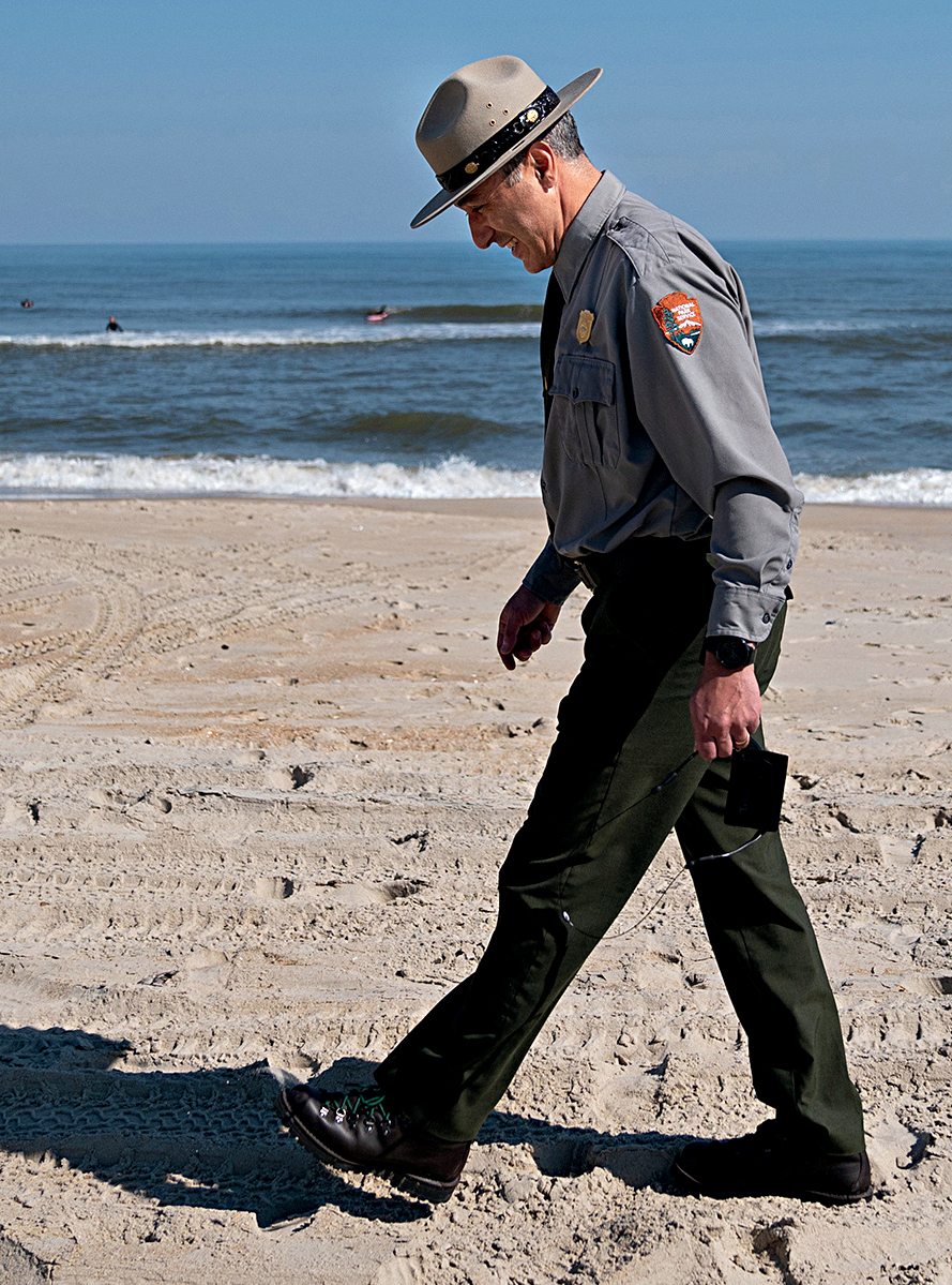
David Hallac, the superintendent of Cape Hatteras National Seashore, Fort Raleigh National Historic Site and Wright Brothers National Memorial, walks along the beach in Avon, one of seven villages on Hatteras Island. Western Carolina University’s Rob Young called Hallac a “superhero superintendent” with one of the hardest jobs in the Park Service.
©ERIN SCHAFF/THE NEW YORK TIMES/REDUXIdeally, owners of at-risk homes would have contractors lined up before their houses fall, and crews would get to work immediately. But it doesn’t usually work that way. After some of the recent collapses, the Park Service has had to step in.
“You’ve got park staff out there cleaning up when they should be doing other things,” said Emily Jones, NPCA’s Southeast regional director. “You just don’t want to see anybody get hurt being on the beach.”
On our stroll, Hallac and I mostly avoided the beachfront, instead walking on the sand behind several homes. “You can’t walk on the beach anymore at high tide because the water is under the houses,” he said. “I’m concerned because just a few weeks ago, you could walk in front of these houses.”
Cape Hatteras National Seashore was established 70 years ago, but for decades, few paid much attention to the park boundaries; after all, those lines — and the water — were football fields away from houses. But natural and human-caused forces have brought those park boundaries (between the mean high and mean low water marks, informally known as the wet sand beach) under some of the oceanfront homes on some days. One homeowner, Jeff Munson, told me that before he moved his house, he would stand on the deck and feel like he was on a cruise ship.
“When houses are intact behind a dune, that’s private property,” said Young. “But you go onto the beach, and that’s Cape Hatteras National Seashore. The problem is that the shoreline is shifting, and homes are effectively moving into the national park.”
Hallac gave the houses a wide berth. Though technically some of these houses may sit on land he manages, he’s sensitive to the concerns of homeowners. He explained that pinpointing the national seashore boundaries is more complicated than simply looking at the wet sand because the shoreline is so dynamic. A formal survey may be required to make the determination between federal land and private property. We walked by a grill mostly buried in the sand. His staff had put up signs here saying the beach was closed, but they washed away.
A biologist by training, Hallac thinks a lot about the resident wildlife. “Imagine you’re a shorebird and you forage in the swash zone,” he said as we lumbered across the sand. “Or if you’re a turtle trying to nest and there are two-by-fours buried in the sand.”

The Rarest Sea Turtle in the World
Staff at Cape Hatteras National Seashore in North Carolina found three nests belonging to the rarest sea turtle species in the world — an animal not commonly found in the…
See more ›As we strolled, I picked up a couple of real estate flyers. One read, “Front Row Seats,” for $459,000. “Views, views, views,” I read off the paper. Later, I learned from a realtor that five people bought oceanfront properties in Rodanthe in the first half of this year.
Hallac and I were walking back to the car when a lanky man with a tape measure clipped on his waistband and a pencil behind his ear stopped us. The contractor didn’t want me to use his name because his view might not be popular, but he told Hallac he was frustrated with investors who now expect bailouts. “Why didn’t they just go to Vegas?” he asked.
More than once, as if reciting a mantra, Hallac said, “There’s no silver bullet.” The lack of a solution keeps him awake at night.
According to Stan Riggs, a geologist who has been studying the North Carolina coast for 60 years, barrier islands like the Outer Banks are “mobile piles of sand.” They are essentially large sandbars, only slightly above sea level, that absorb the impact of surges and protect the mainland from extreme weather. With each storm surge, waves wash over the barrier islands; over time, the overwash moves the islands toward the coast. Or at least that’s how it’s supposed to work. But on Hatteras, that movement is altered by human-made structures — the homes, roadways and bridges that have been built to support a growing population and millions of annual visitors.
I went to visit Coastal Studies Institute Executive Director Reide Corbett on Roanoke Island, just north of the national seashore, and he pulled up an interactive map showing coastal erosion over the decades. He pointed out that most of the Outer Banks are also eroding from the sound side, albeit at a slower rate. “The islands are doing this,” he said, pushing his palms together to demonstrate “coastal squeeze.” Other communities around the country are dealing with similar issues, but that squeeze is particularly dramatic here. The Outer Banks “could be a canary in the coal mine,” Corbett said.
Nourishment projects don’t help one bit — they just make people feel good for a brief period.
Cape Lookout National Seashore, about 100 miles southwest of Rodanthe as the crow flies, provides a compelling comparison. Those islands, accessible only by boat for the most part, are wild and undeveloped, with no paved roads and no human residents. They are also among the healthiest islands in the world, said Riggs.
“Once you quit trying to fool with it,” he said, “nature builds those islands. They belong to the ocean.”
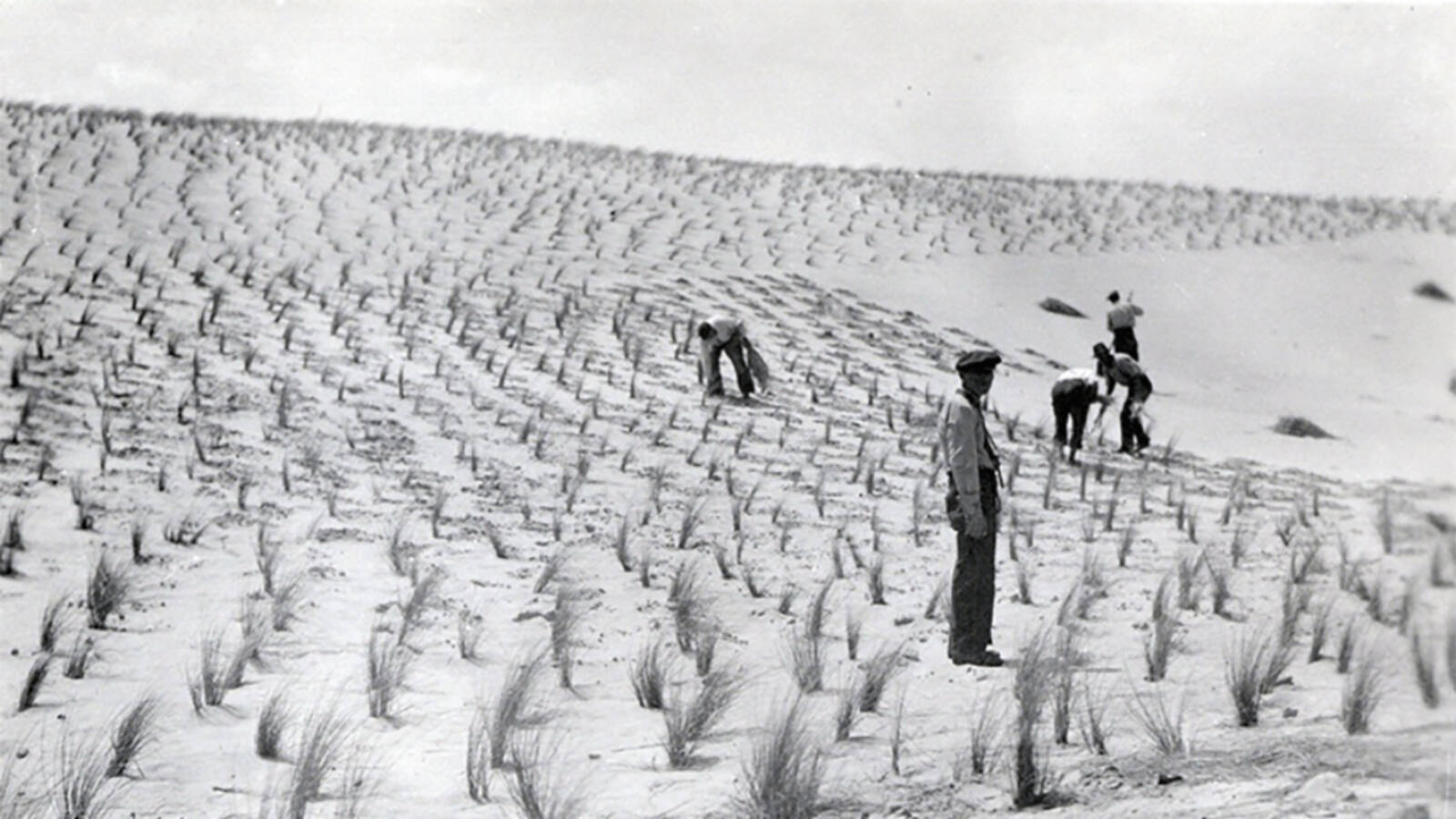
Hallac had given me a helpful lesson on the history of local coastal management when we were driving around. In 1936, Congress passed a beach improvement act that made it federal policy to help protect beaches from erosion. That same year, the Park Service took over a massive dune-building effort from the Civilian Conservation Corps on the Outer Banks. Thousands of workers installed several million feet of fencing, and they planted grasses as well as millions of trees in hopes of halting erosion. From the beginning, it was understood that this Great Wall of Carolina, as critics later called it, would have to be continually reconstructed.
In the decades after Cape Hatteras National Seashore was established, scientists began to better understand barrier islands. Experts concluded that the dune projects were actually preventing the movement of sand and worsening erosion. So in the ’70s, the Park Service reversed course and stopped trying to hold back the ocean.
These days, there are three standard responses to shoreline erosion. One — building hard structures such as jetties and sea walls — was banned in North Carolina in 2003 because those structures ultimately cause an increase in erosion in other areas of the beach. The second is retreat or relocation of existing buildings, parking lots and roads, which essentially means allowing the coast to be reshaped. The third is beach nourishment. Young said nourishment is an economic lifesaver for hundreds of coastal communities, noting that Miami, Virginia Beach and Wrightsville Beach, North Carolina, wouldn’t have beaches today if not for these projects.
In 2011, Nags Head was partway through a major nourishment project when Hurricane Irene hit. After the storm subsided, county officials were gobsmacked to find no damage to houses or hotels, no flooding, no sand on the roads. Suddenly, many locals, including those who had previously dismissed the idea of nourishment, wanted in.
As helpful as nourishment is for tourism and local economies, these projects are controversial. For starters, the process does not stop erosion. “Our present economic approach to development on the barriers is not sustainable over the long term, and nourishment projects don’t help one bit — they just make people feel good for a brief period,” said Riggs.
A Reporter ‘On the Brink’ at Cape Hatteras
Near Cape Hatteras, the rising ocean is causing homes to collapse, creating devastating losses and dangerous conditions. Journalist Melanie D.G. Kaplan shares what she learned while reporting on the crisis.
See more ›The new beaches may last three to five years, depending on storm activity and erosion rates, before more sand is needed. “This is a forever game,” Young said. “It’s like something out of Dante’s ‘Inferno.’” He’s concerned that nobody has a Plan B or knows the ecological impact of trying to build “one giant beach from southern Maine to South Padre Island, Texas.”
Beach nourishment work is also expensive. NOAA’s database shows that the U.S. has spent close to $9 billion on nourishment in the last century, sometimes paying $10 million or more per mile. A report commissioned by Dare County, released in May, estimated that nourishing just over 2.5 miles of beach in Rodanthe would cost $40 million.
Although undertaking beach nourishment in a national park is permissible if the project meets the stringent criteria required for a permit, neither federal law nor park management policy point toward nourishment as an appropriate first-choice solution, said Furr Youngman, the environmental lawyer. She stressed that most of these projects are not compatible with the Park Service’s mission — to preserve “unimpaired the natural and cultural resources and values of the National Park System for the enjoyment, education, and inspiration of this and future generations.”
Hallac said the Park Service doesn’t generally use beach nourishment unless one of its buildings or a road used by staff and visitors needs protection. “We don’t have anything in Rodanthe that needs to be protected,” he said. “It’s not that beach nourishment is a priority or not; it’s just not our role to protect neighboring communities.”
Park policy calls for looking at the best available science, trying to forecast where the shoreline will be in the future and determining what makes sense for park structures on a case-by-case basis, Hallac said. In 1999, the iconic Cape Hatteras Lighthouse, which was built 1,500 feet from the ocean in 1870, was moved a half-mile inland after the water came as close as 120 feet.
The Park Service’s approach isn’t always popular. Homeowner Daniel Kerlakian purchased an oceanfront house in Rodanthe in 2021 and has spent most of the last two years repairing storm damage and reinforcing his home. Kerlakian loves national parks but is frustrated that the Park Service isn’t rebuilding the shore. “I strongly believe that the national seashore is not a national seashore in front of Rodanthe anymore,” he said, “because the park failed to maintain it.”
Homeowners, many of whom rent out their properties, face difficult decisions. Some may be hoping the government comes through with funding for beach nourishment or for relocation or removal of their houses. Or they are waiting until their houses fall in the water, at which time — and not a minute before — they may be able to collect insurance money.
Others, whose homes have been declared uninhabitable, are crunching numbers to see if they can come up with the funds to cover their mortgage and move their home without rental income, which can reach $5,000 a week at the height of the season. Even if they have the financing in place, relocation is complicated. Multiple permits must be in order. Weather, tides and nesting turtles can hold up the process, sometimes for months.
Last September, Expert House Movers moved Doughty’s house 200 feet westward, and when I visited, it was in its new location, waiting to be lowered onto new pilings. At the current rate of erosion, Doughty bought herself — for a couple of hundred thousand dollars — a decade and change.
One solution the Park Service is exploring, according to Hallac, is buyouts of the homes teetering on the shoreline. Young has estimated it would cost $43 million to buy the 80 properties within 300 feet of the high-tide line. (Young’s report shows only one of the 80 is a primary residence.) Buying out homes will give Rodanthe a viable beach for 15 to 25 years at about one-third the cost of nourishing a similar stretch of beach for that same period. Based on the numbers, Young said buyouts are a no-brainer. But first, homeowners must agree to sell, and he can’t think of one coastal community that has done this. “This is such an important conversation, and it’s absurd to me that this is still such a controversial idea,” he said.
Riggs said that if we want healthy barrier islands in the future, we must move off the oceanfront and let the barrier respond to the ocean dynamics. “This doesn’t mean we abandon the barriers,” he said. “We just need to get smarter about how and where we live on a barrier island.”
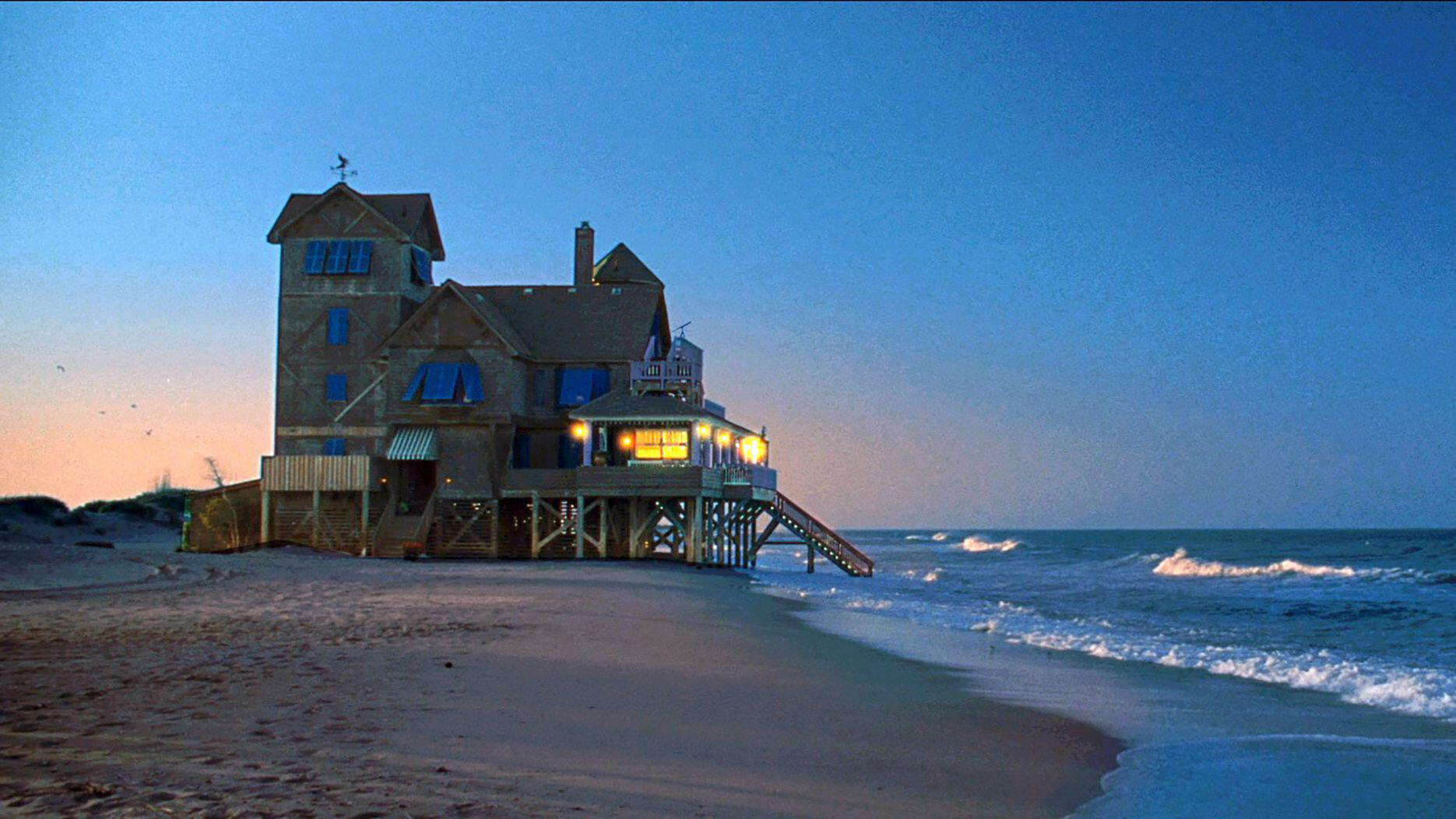
Serendipity, the house featured in the movie “Nights in Rodanthe,” as pictured in
2008 before being moved back.
Many people aren’t happy with the idea of managed retreat, but today we have what Young calls unmanaged retreat. “Doing nothing is an option that shouldn’t be on the table,” he said.
One evening during my visit, Dare County Manager Bobby Outten led a public meeting at the community center in Rodanthe. The one-room building was packed: Close to 100 people, including the sheriff, sat or stood. A virtual crowd watched online. Outten ran through a slideshow explaining beach nourishment and how projects have been funded in the past — using revenues generated partly from an occupancy tax. He explained that the county’s nourishment fund, currently $6 million, won’t come close to covering a Rodanthe project. He said he would like to see a nourishment project in the village but has exhausted his search for funding.
After the meeting I returned to my Airbnb, a small apartment on the sound side of Rodanthe. I queued up “Nights in Rodanthe,” the 2008 movie with Richard Gere and Diane Lane. Much of the story takes place at an inn and was shot on location in Rodanthe. At several points, I paused the movie to watch and re-watch waves dancing under the house, which seemed lovely, romantic even. I also now understood that only in Hollywood is water under a house desirable. The large house, once called Serendipity, has since been moved away from the ocean. The next morning, on my way out of town, I stopped to see it. The road was full of sand, and the pavement looked like it has been punched with a wrecking ball. Serendipity is currently on the market for $1.5 million.
This spring, the North Carolina Coastal Resources Commission approved changes in the rules about permits for replacing or moving septic systems on public beaches, which will add hurdles for homeowners who wish to reinstall systems in vulnerable areas. The commission also approved rules that would require real estate disclosures about flood history and flood risk. Meanwhile, homeowners, the Park Service and various experts continue their efforts to figure out the best way forward.

National Parks
You can read this and other stories about history, nature, culture, art, conservation, travel, science and more in National Parks magazine. Your tax-deductible membership donation of $25 or more entitles…
See more ›Back home, almost two months after my visit, I talked to Doughty, who said her contractor recently poured the concrete for her house’s foundation. The next morning, she emailed a few overhead shots someone had sent her from Rodanthe. In one picture, the deep green ocean pushed large waves up under homes that Hallac and I had walked behind.
A few hours later, she called to tell me that one of the houses had fallen into the ocean. I was surprised how sad I felt hearing this news. The ocean quickly spread debris between the north end of Rodanthe and the south end of Avon. Park Service employees would eventually remove 70 pickup truckloads of wreckage from the beach.
In the days after the collapse, I watched videos from the Island Free Press and local TV stations showing the house after its pilings gave way but before it broke apart in the waves and its pieces looked like Tinkertoys in a jacuzzi. For that short time before the ocean had her way, the house sat tilting east, surrendering to the sea, a rental sign still clinging to its shingles.
About the author
-
 Melanie D.G. Kaplan Author
Melanie D.G. Kaplan is a Washington, D.C.-based writer. Her first book, "Lab Dog: A Beagle and His Human Investigate the Surprising World of Animal Research," was published in 2025. Learn more at melaniedgkaplan.com.
-
Press Release
New Report Explores Future Opportunities for a Restored Mississippi River
Our "Reimagining the River," report reveals opportunities to expand recreation, strengthen community connections, and generate economic benefits for the Twin Cities region.
-
Press Release
Senate Committee Advances Critical Bill to Fix National Parks
"As America approaches its 250th anniversary, there’s no better way to honor this milestone than by investing in the places that protect and tell our shared history." - Emily Douce,…
-
Press Release
Coalition Files Suit, Unites to Save West Potomac Park from Unlawful Trump Transformation
Irreplaceable National Park Site Threatened By Proposal for Another Trump Construction Project


